
Most of us grow up with a simple idea of what a country looks like on a map. One color ends at a border, another begins, and somewhere along that line there may be a checkpoint, a customs office or a sign welcoming you to a different nation.
But political geography is not always that tidy.
There are places where a piece of one country is completely surrounded by another. Rarer still are places where, after entering that isolated territory, you can cross yet another boundary and find yourself back in the country you started from.
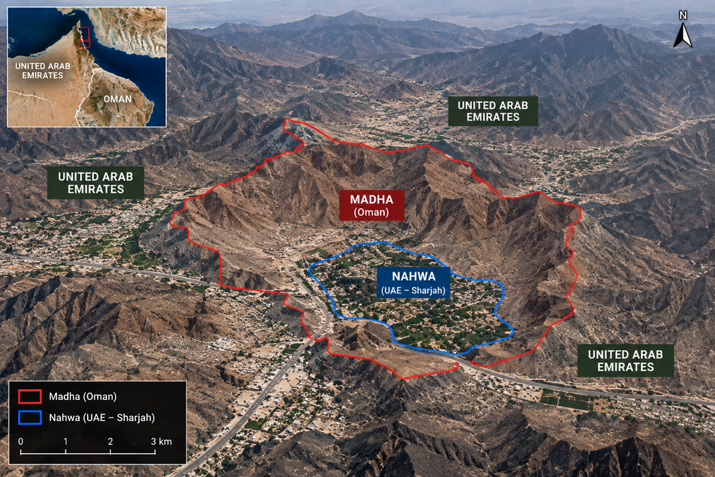
One such geographical puzzle still exists today between Oman and the United Arab Emirates.
An even more extraordinary one survived between India and Bangladesh until 2015. At its most complicated point, the territorial sequence could be described as:
Bangladesh → India → Bangladesh → India.
At the center was a tiny agricultural plot called Dahala Khagrabari #51, widely described as the world’s only third-order enclave before the India–Bangladesh enclave exchange eliminated its unusual status in 2015.
This sounds like geography designed as a riddle. In reality, it is what happens when centuries of political history remain embedded in modern borders.
First, what exactly is an enclave?
An enclave is a territory surrounded entirely by another territory. When viewed from the perspective of the country to which it belongs, such an area can also be an exclave because it is geographically separated from the country’s main territory.
That alone can create some unusual maps.
But imagine that Country A has a small territory entirely inside Country B. Now imagine that within that piece of Country A there is another piece belonging to Country B.
That inner territory is known as a counter-enclave, or a second-order enclave.
Add one more territorial layer and you have something extraordinarily rare: a third-order enclave.
For years, this was not merely a theoretical possibility.
It actually existed.
A tiny field at the center of a geopolitical maze
Dahala Khagrabari #51 was Indian territory. At roughly 7,000 square meters, or around 1.7 acres, it was not much larger than a football field.
Despite the dramatic way the location is sometimes presented online, there was no hidden town trapped at its center. It was essentially agricultural land rather than a populated settlement. Contemporary reporting described the plot as being owned by a Bangladeshi farmer living in the surrounding area.
What made it extraordinary was not what stood on the land, but what surrounded it.
Dahala Khagrabari belonged to India.
Around it was Upanchowki Bhajni, which belonged to Bangladesh.
That territory was itself located inside Balapara Khagrabari, belonging to India.
And around Balapara Khagrabari was Bangladesh.
Starting from the outside and moving inward, therefore, you encountered:
Bangladesh → India → Bangladesh → India.
The final Indian layer was Dahala Khagrabari.
It looked like the sort of mistake that might appear when digital mapping software fails to load correctly.
It wasn’t.
The famous chess story is probably too good to be true
Whenever the history of the India–Bangladesh enclaves is told, one explanation tends to dominate.
According to a colorful local legend, rulers in Cooch Behar and Rangpur enjoyed gambling with villages as stakes, sometimes while playing chess. A ruler would win a village deep inside his rival’s territory, the other would win another one in return, and generations of such wagers supposedly produced the fragmented landscape.
It is an irresistible story.
It is also not a reliable explanation of how the enclaves were created.
Historical scholarship instead traces their origins to a much more complicated period of competing jurisdictions, territorial control and conflict involving the Kingdom of Cooch Behar and Mughal authorities.
The important point is that territory did not always work the way we expect a modern nation-state to work. Political control, land ownership, taxation and allegiance could overlap in ways that did not require every ruler’s possessions to form one continuous block.
An isolated tract of land could therefore survive inside territory controlled by someone else without creating the kind of international crisis it would cause today.
Centuries later, however, those old arrangements acquired an entirely different meaning.
Old territorial fragments became international borders
The partition of British India in 1947 transformed the region.
Cooch Behar eventually became part of India, while Rangpur was located in East Pakistan. East Pakistan later became the independent nation of Bangladesh in 1971.
The old territorial fragments did not conveniently disappear when the modern states emerged.
What had once been a complicated legacy of local rule was now divided by an international border.
A piece of one sovereign nation could be completely surrounded by another sovereign nation.
And these were not merely curiosities for cartographers.
People lived inside many of them.
For residents, strange geography had real consequences
A bizarre border makes for a fascinating map. Living inside one is another matter entirely.
Residents of the India–Bangladesh enclaves could face difficulties accessing public services and infrastructure precisely because the country responsible for them was physically separated from them by another country’s territory.
Schools, electricity, medical services, roads, administrative documents and law enforcement could all become complicated when reaching the rest of your own country involved crossing an international boundary.
The scale of the problem was considerable.
A joint India–Bangladesh census conducted in 2011 counted 51,549 people living in the enclaves: 37,334 in Indian enclaves inside Bangladesh and 14,215 in Bangladeshi enclaves inside India, according to India’s Ministry of External Affairs.
So behind the peculiar lines on the map were tens of thousands of lives affected by a territorial arrangement inherited from a very different political era.
It took decades to untangle the border
India and Bangladesh did not suddenly discover the problem in 2015.
Efforts to settle their complicated land boundary stretched back decades. The two countries signed a Land Boundary Agreement in 1974, followed by a protocol in 2011. Full implementation, however, required additional political and legal steps.
That finally happened in 2015.
Under the settlement, 111 Indian enclaves located inside Bangladesh, covering roughly 17,160 acres, were transferred to Bangladesh. In the opposite direction, 51 Bangladeshi enclaves inside India, covering approximately 7,110 acres, became Indian territory.
The agreement also addressed citizenship choices for affected residents.
What sounds like a simple exchange of colored shapes on a map was therefore something much more significant: an attempt to make political geography correspond more closely with the reality of the people living there.
And the exchange had one remarkable side effect.
It erased one of the strangest geographical anomalies on Earth.
The world’s third-order enclave disappeared
When the new arrangement took effect around the transition from July 31 to August 1, 2015, Dahala Khagrabari ceased to be an isolated piece of India.
The tiny plot became part of Bangladesh along with the territory surrounding it.
The extraordinary territorial nesting was gone.
No more Bangladesh containing India containing Bangladesh containing India.
A geographical arrangement that had fascinated cartographers and border enthusiasts simply ceased to exist.
Yet a less extreme version of the same phenomenon can still be found thousands of kilometers away.
Oman and the UAE still have their own geographical nesting doll
Travel to the eastern side of the United Arab Emirates and another unusual border appears.
Madha belongs to Oman.
Geographically, however, Madha is separated from the main territory of Oman and surrounded by the United Arab Emirates.
That would already make it unusual.
But inside Madha sits Nahwa, which belongs to the Emirate of Sharjah and therefore to the United Arab Emirates.
The result is:
United Arab Emirates → Oman → United Arab Emirates.
Nahwa is therefore a counter-enclave — a territory belonging to the UAE located inside an Omani enclave that is itself surrounded by the UAE. Sharjah’s official tourism information describes this unusual second-order enclave arrangement.
Unlike Dahala Khagrabari, this geopolitical nesting doll still exists.
Why didn’t Madha simply become part of the UAE?
The answer again lies in history rather than geography.
The modern borders of this region developed from local political allegiances that predated the creation of the United Arab Emirates in 1971.
Historical reporting on Madha describes how its inhabitants aligned themselves with Oman, while neighboring communities were associated with rulers of what would become individual emirates. Nahwa, meanwhile, remained associated with Sharjah.
Once those allegiances became incorporated into modern political boundaries, the result was the unusual arrangement visible today.
Madha became Omani territory surrounded by the UAE.
Nahwa remained UAE territory surrounded by Madha.
History had effectively created a geographical nesting doll.
Crossing the border may be far less dramatic than the map suggests
Looking at the map, it would be reasonable to imagine a succession of immigration booths and barriers: leave the UAE, enter Oman, then leave Oman and re-enter the UAE.
The experience on the ground can be surprisingly different.
Reporting from the region has described the Madha–Nahwa boundaries as lacking the conventional secured border infrastructure travelers might expect elsewhere between Oman and the UAE. In accounts of journeys into Madha, even a mobile phone switching to an Omani network can become one of the clues that the traveler has crossed into another country.
Road signs, flags, infrastructure and other details make the territorial change more apparent as the journey continues.
That contrast is part of what makes Madha and Nahwa so fascinating.
A line that looks extraordinary on a political map can feel almost understated on the ground.
Yet legally, the journey remains remarkable:
UAE → Oman → UAE.
Viral videos often merge two different geographical stories
This is worth clarifying because posts about these borders frequently place maps and footage from different regions side by side.
Dahala Khagrabari and Madha–Nahwa are not the same place.
They are two separate examples of territorial enclaves.
The India–Bangladesh case represented the more extreme configuration:
Bangladesh → India → Bangladesh → India.
It disappeared in 2015.
The Arabian Peninsula example remains:
United Arab Emirates → Oman → United Arab Emirates.
Dahala Khagrabari was a third-order enclave. Nahwa is a second-order enclave, or counter-enclave.
Both, however, reveal something much larger than an amusing geographical oddity.
Borders are history drawn onto the landscape
Modern political maps can give us the impression that countries are natural geographical objects. Each receives a different color, and neat lines tell us exactly where one ends and another begins.
History is rarely so orderly.
Borders can preserve the consequences of wars, treaties, land ownership, local allegiances, colonial administration and political compromises made generations or even centuries earlier.
Sometimes those decisions produce an almost straight line across a map.
Sometimes they leave a village on one side and its neighbors on another.
And occasionally they produce something as improbable as Dahala Khagrabari: a tiny piece of India inside Bangladesh, inside India, inside Bangladesh.
That is why places like these are more than geographical trivia.
A border is not merely a line separating two colors on a map. It can be the surviving imprint of decisions made by people who lived in an entirely different political world.
Sometimes history isn’t simply recorded in books. It remains physically drawn across the map.